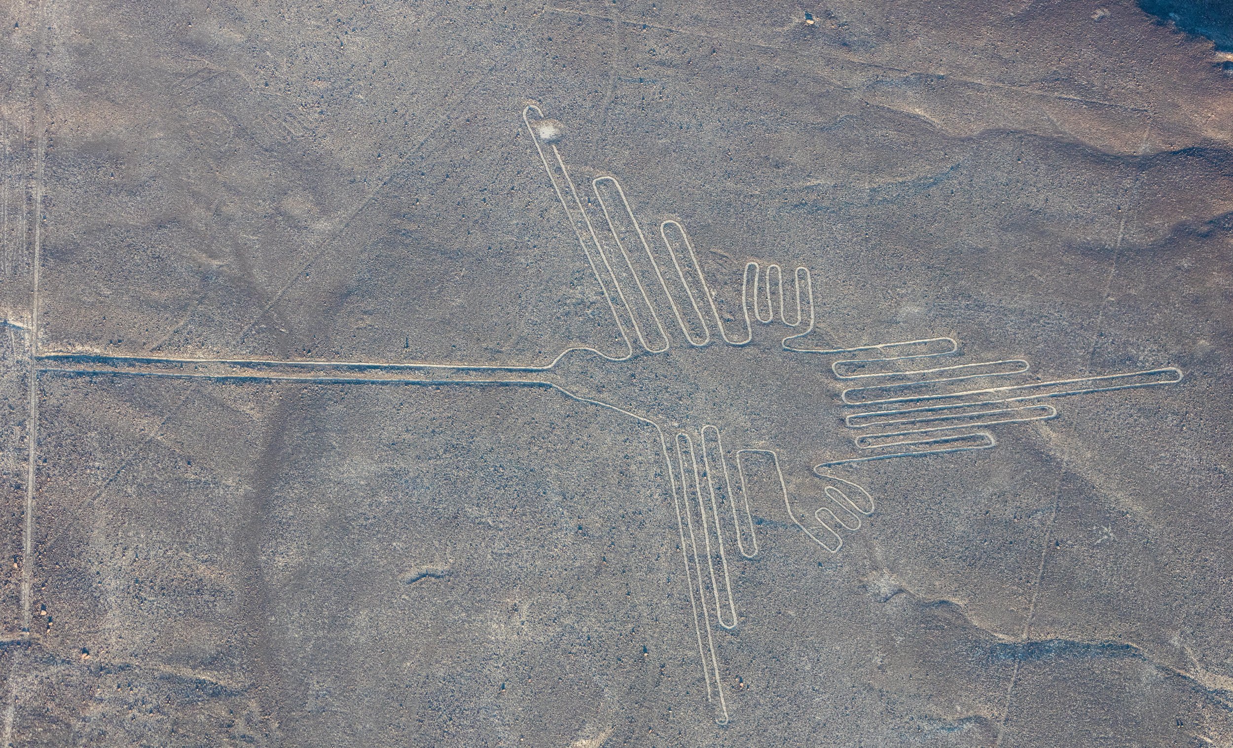
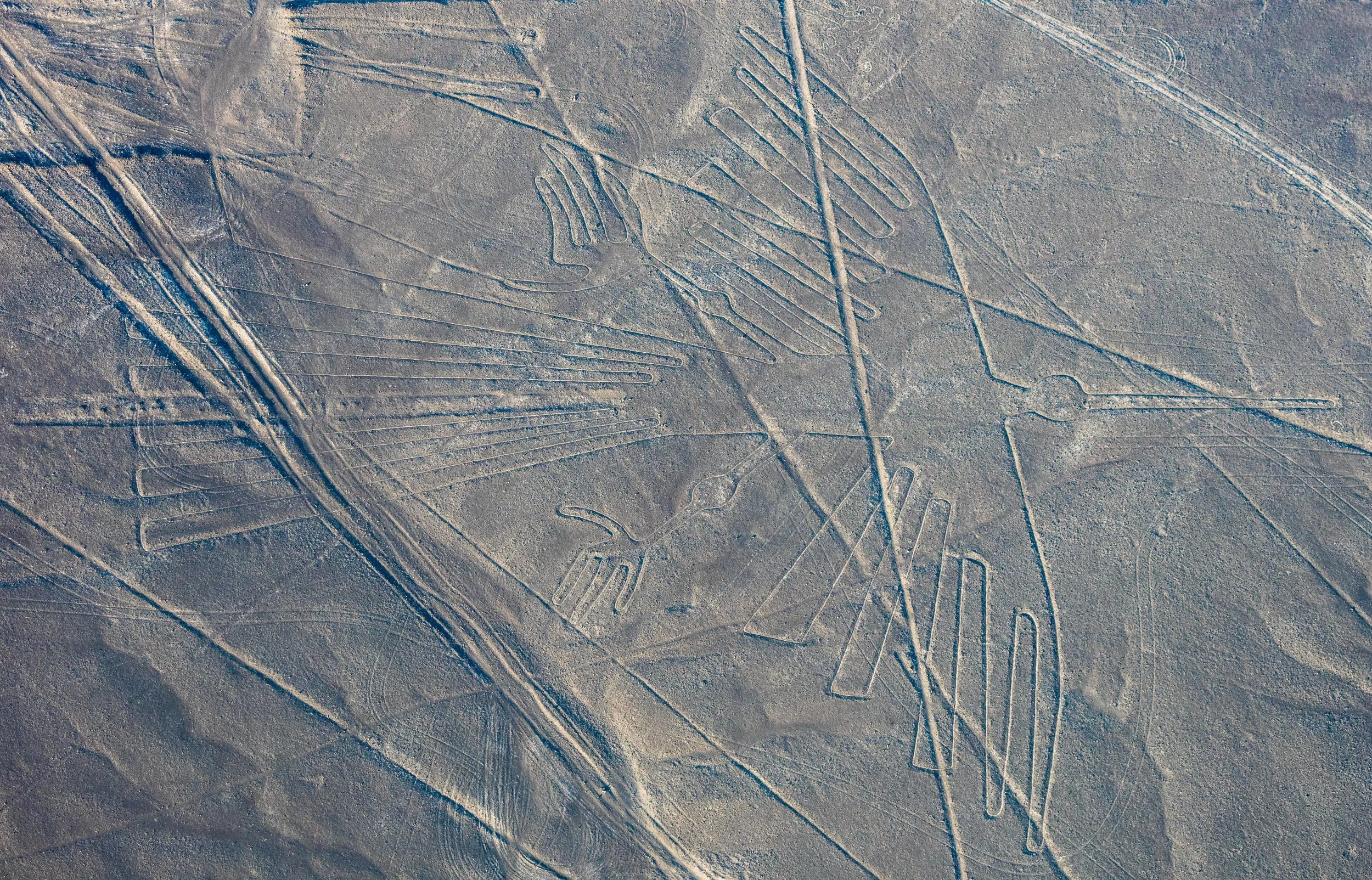
El colibrí (hummingbird)
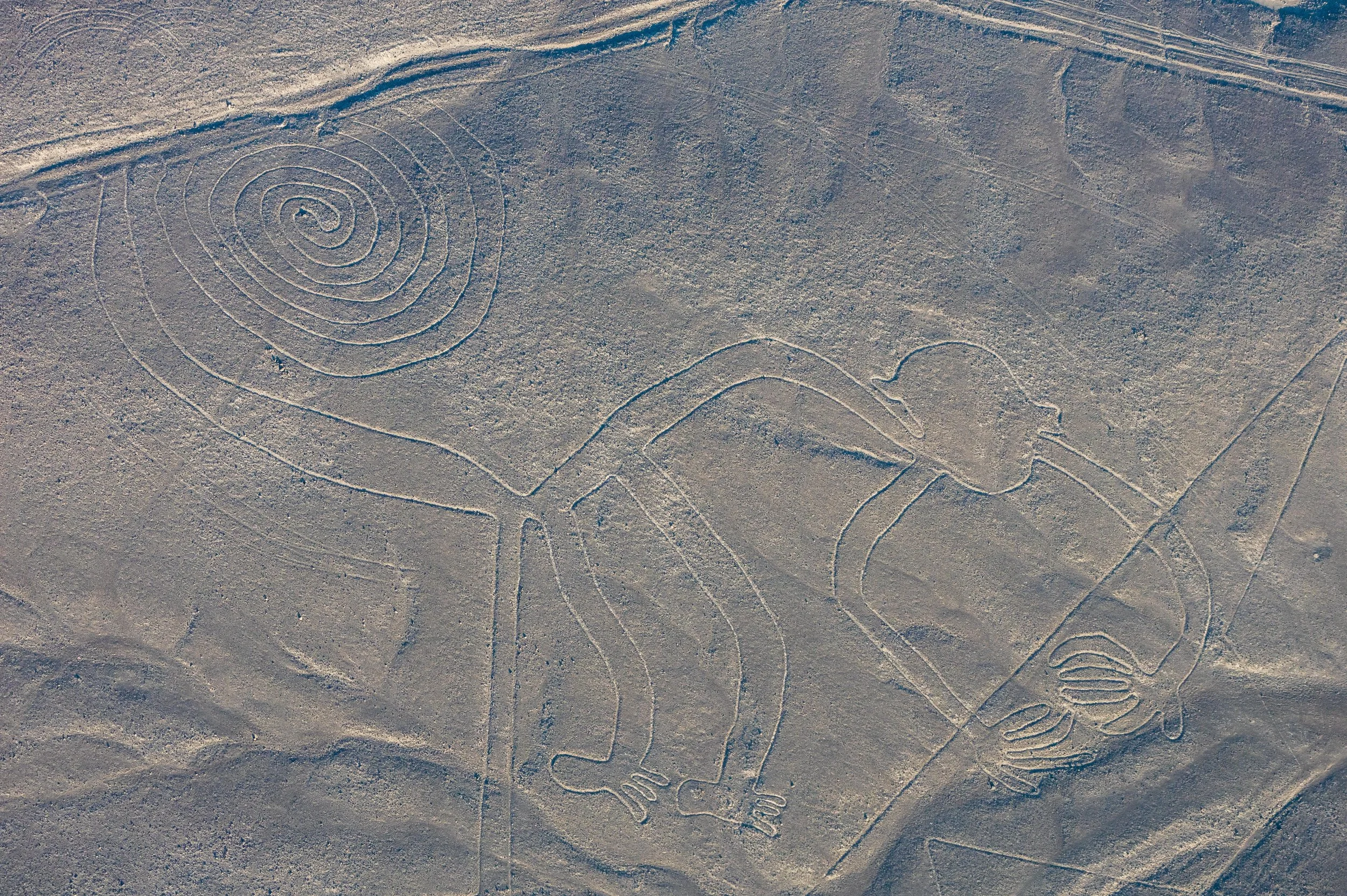
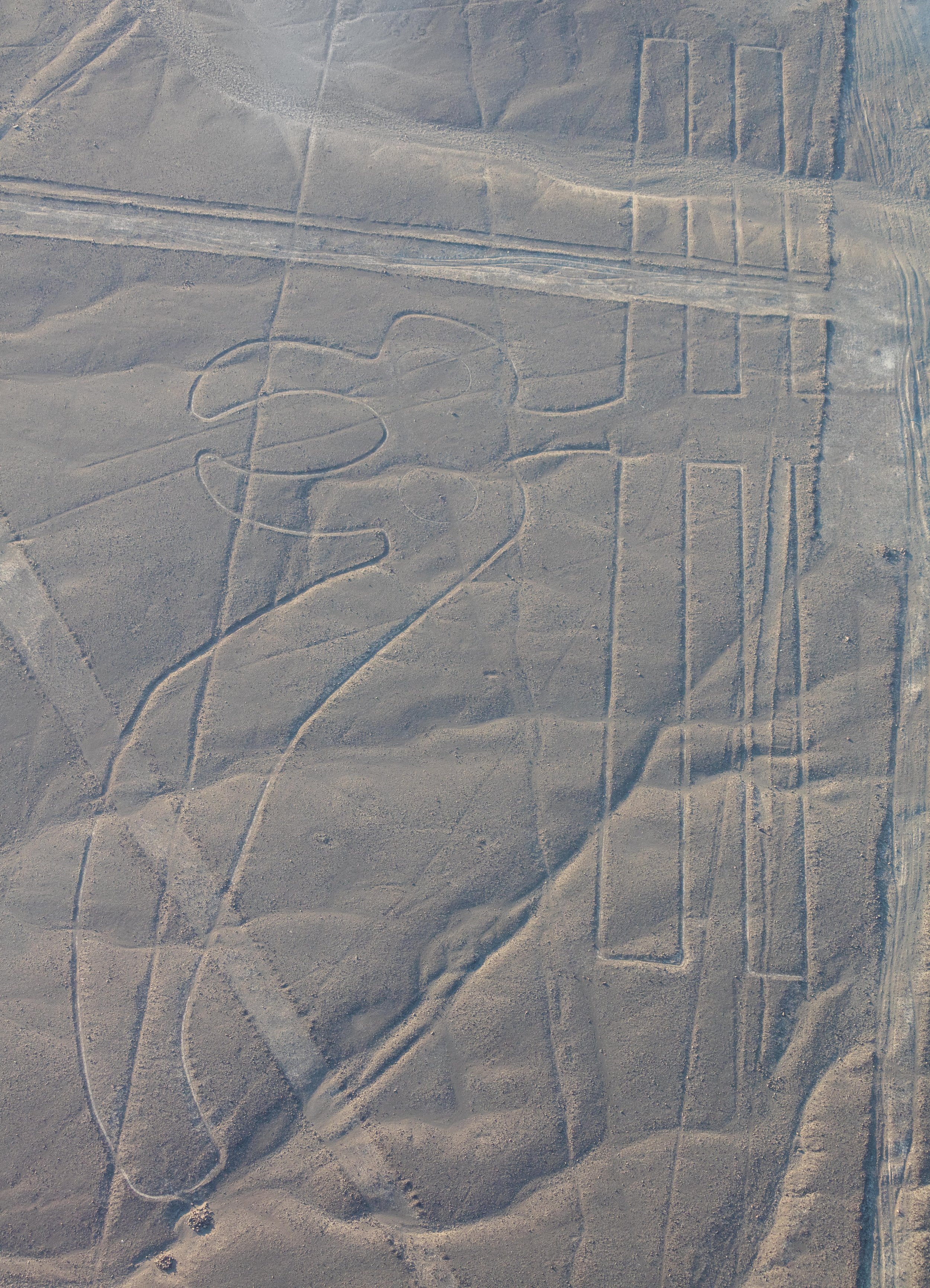
El mono (monkey)
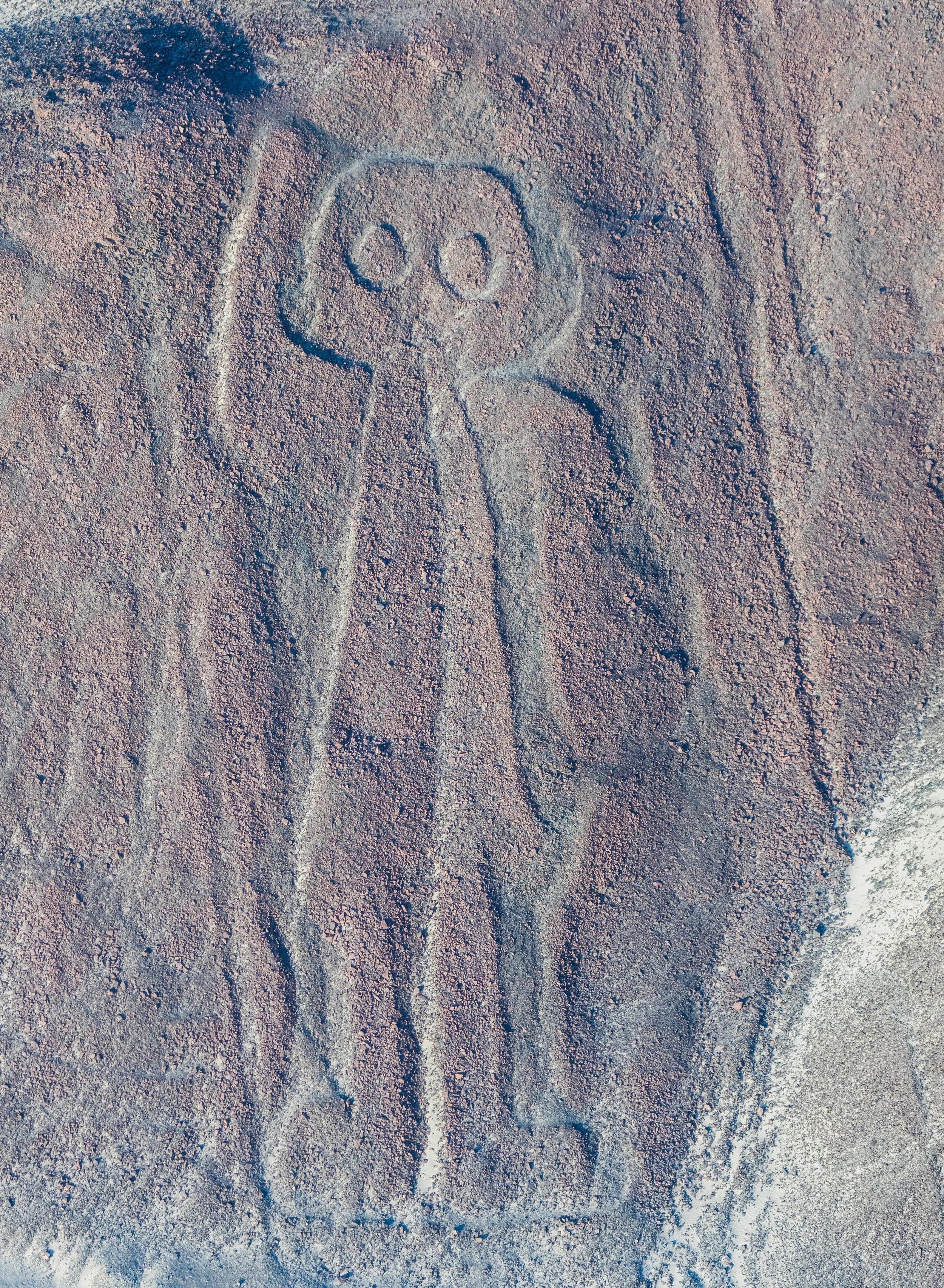
Aerial view of the "Owlman" aka "Astronaut", the most enigmatic geoglyph of the Nazca Lines
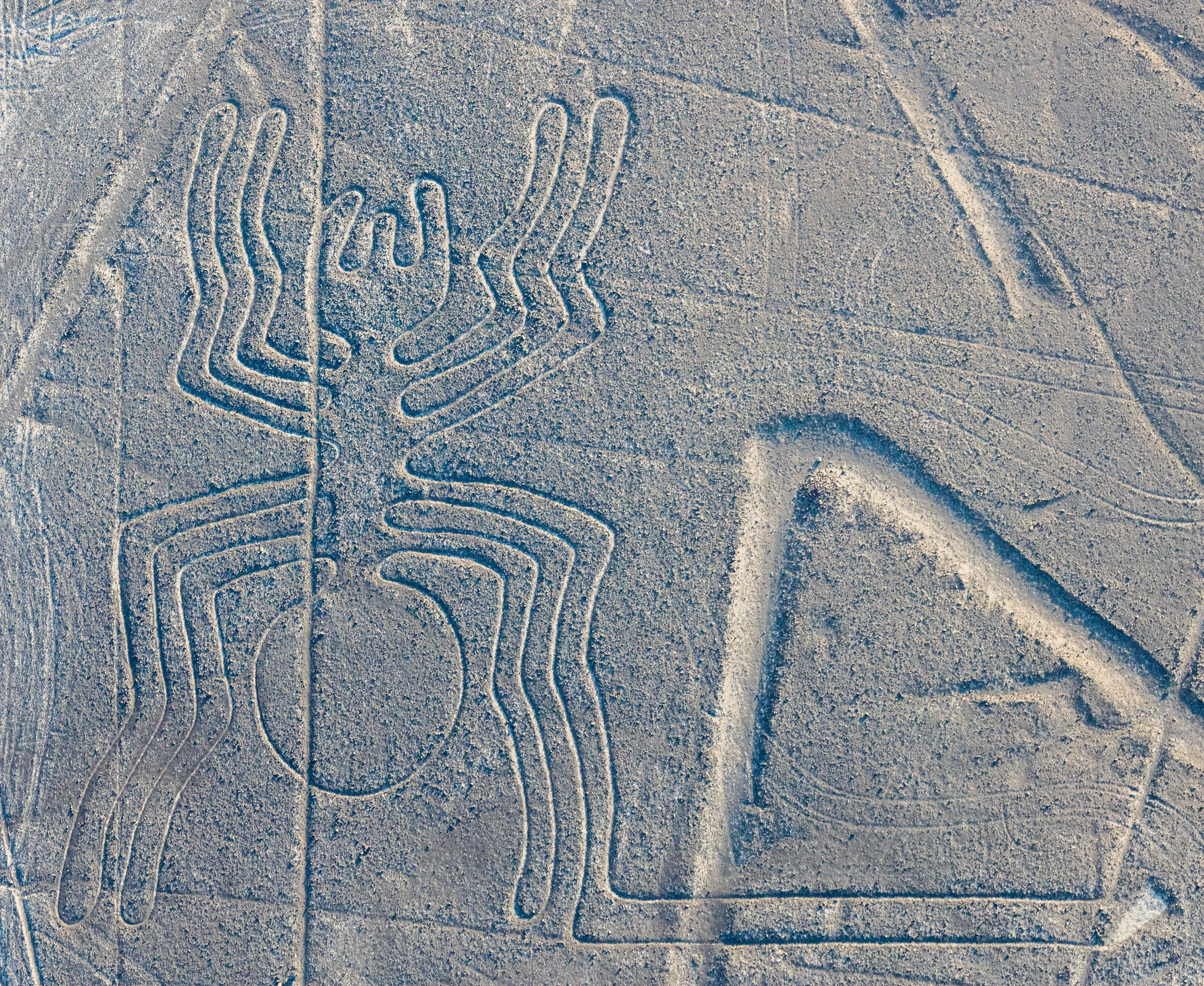
La araña (spider)
El árbol (tree)
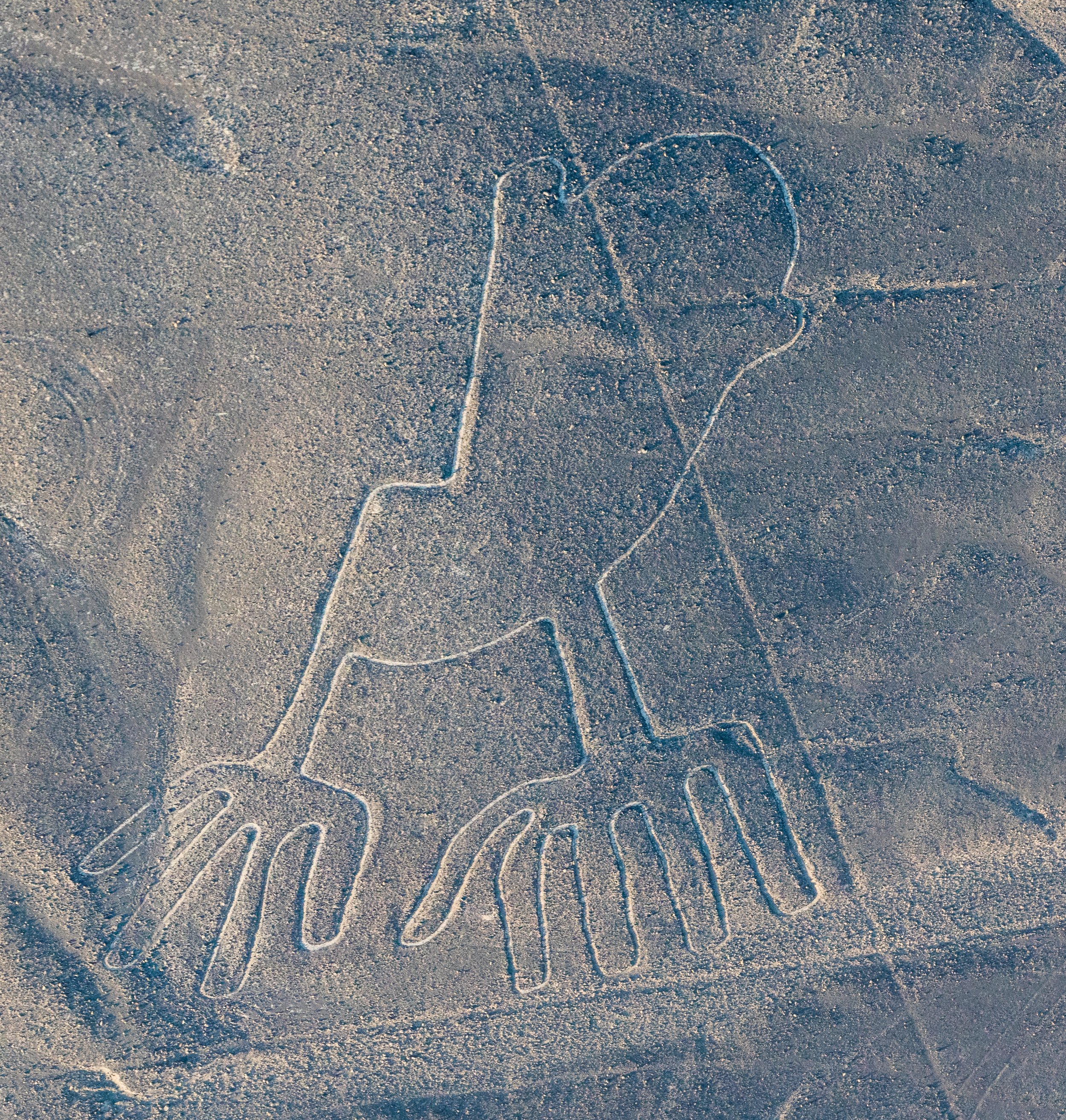
Las manos (hands)
El loro (parrot)
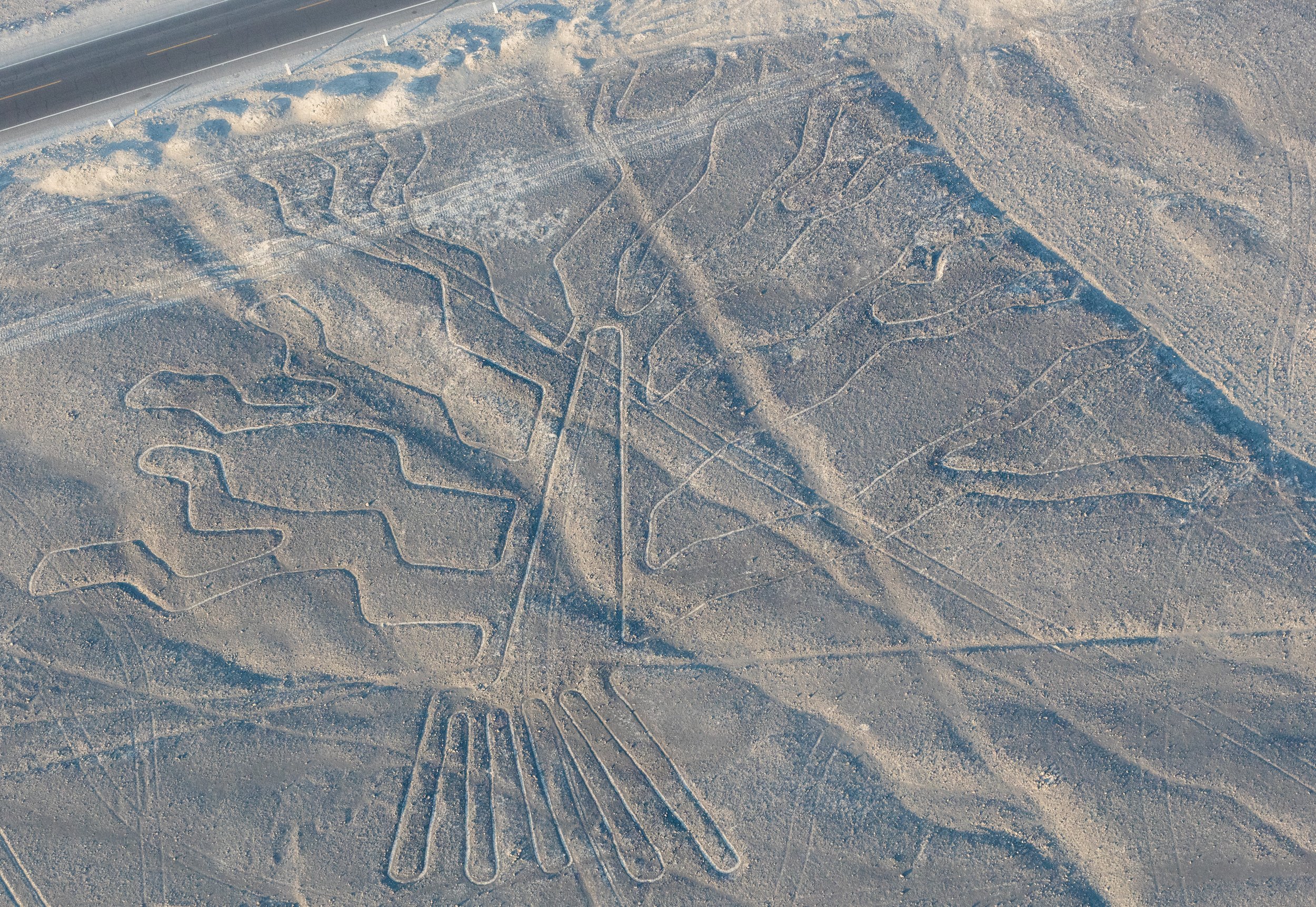
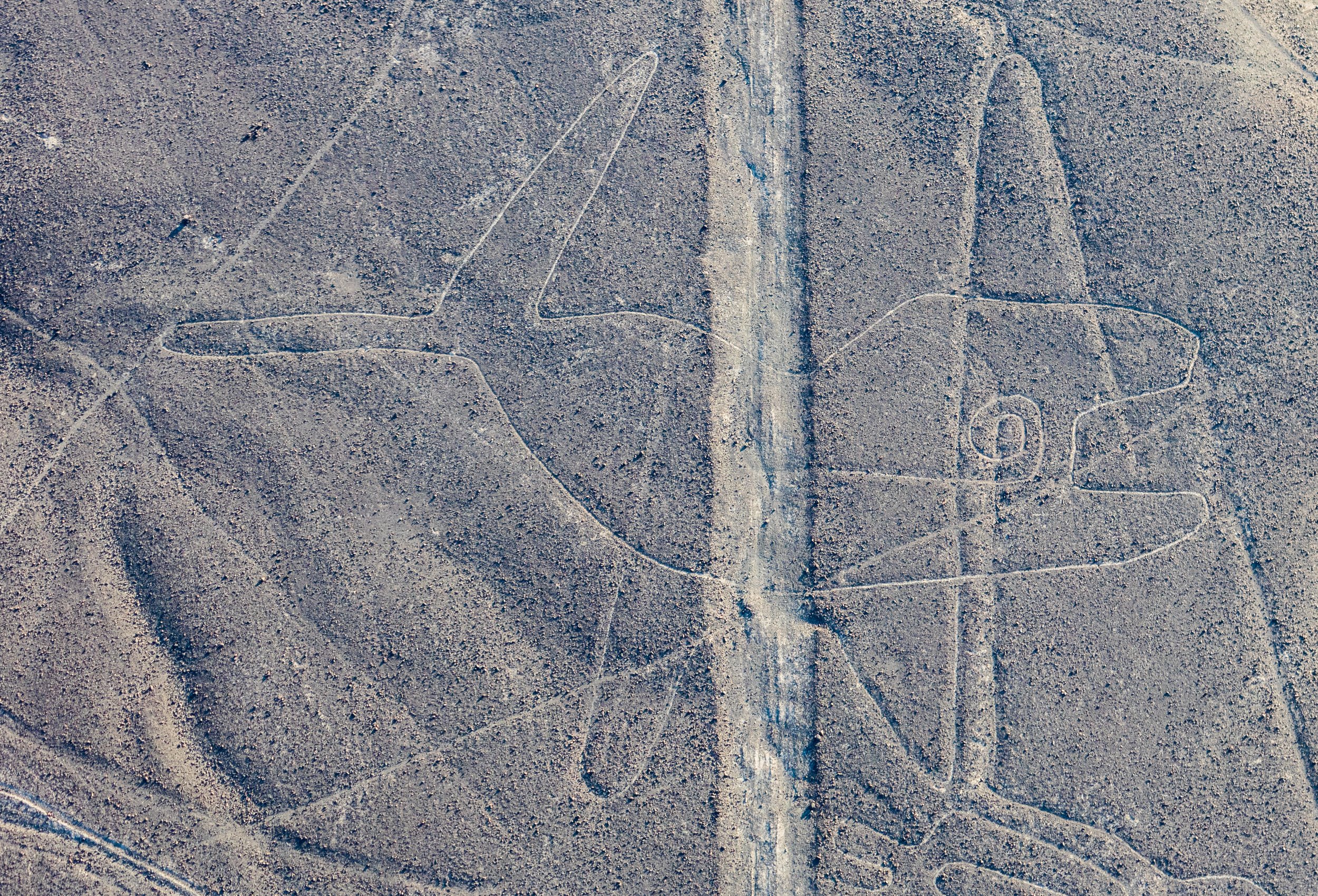
El cóndor (condor)
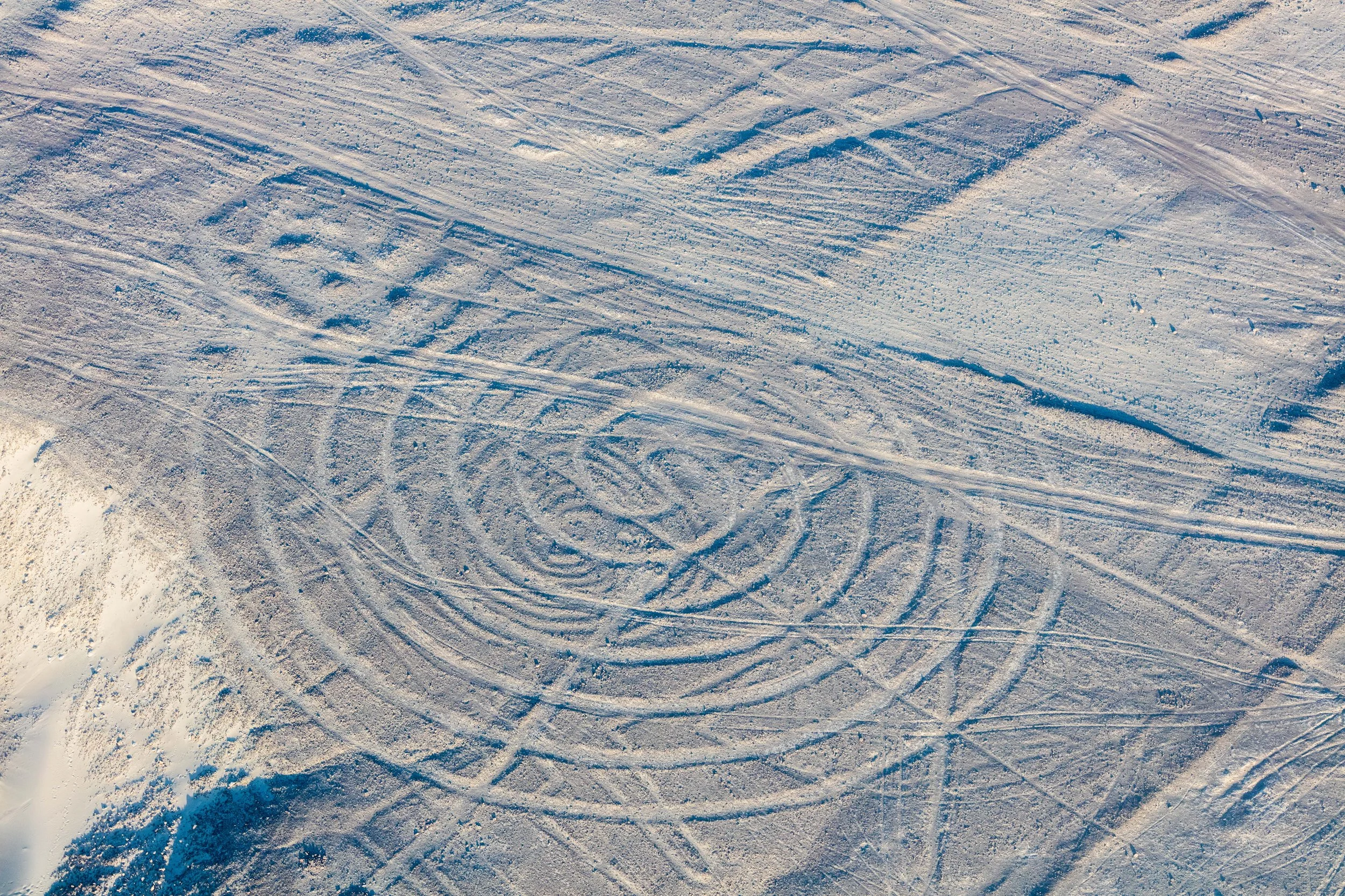
La espiral (spiral)
La ballena (whale)
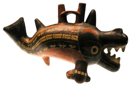
Nazca pottery
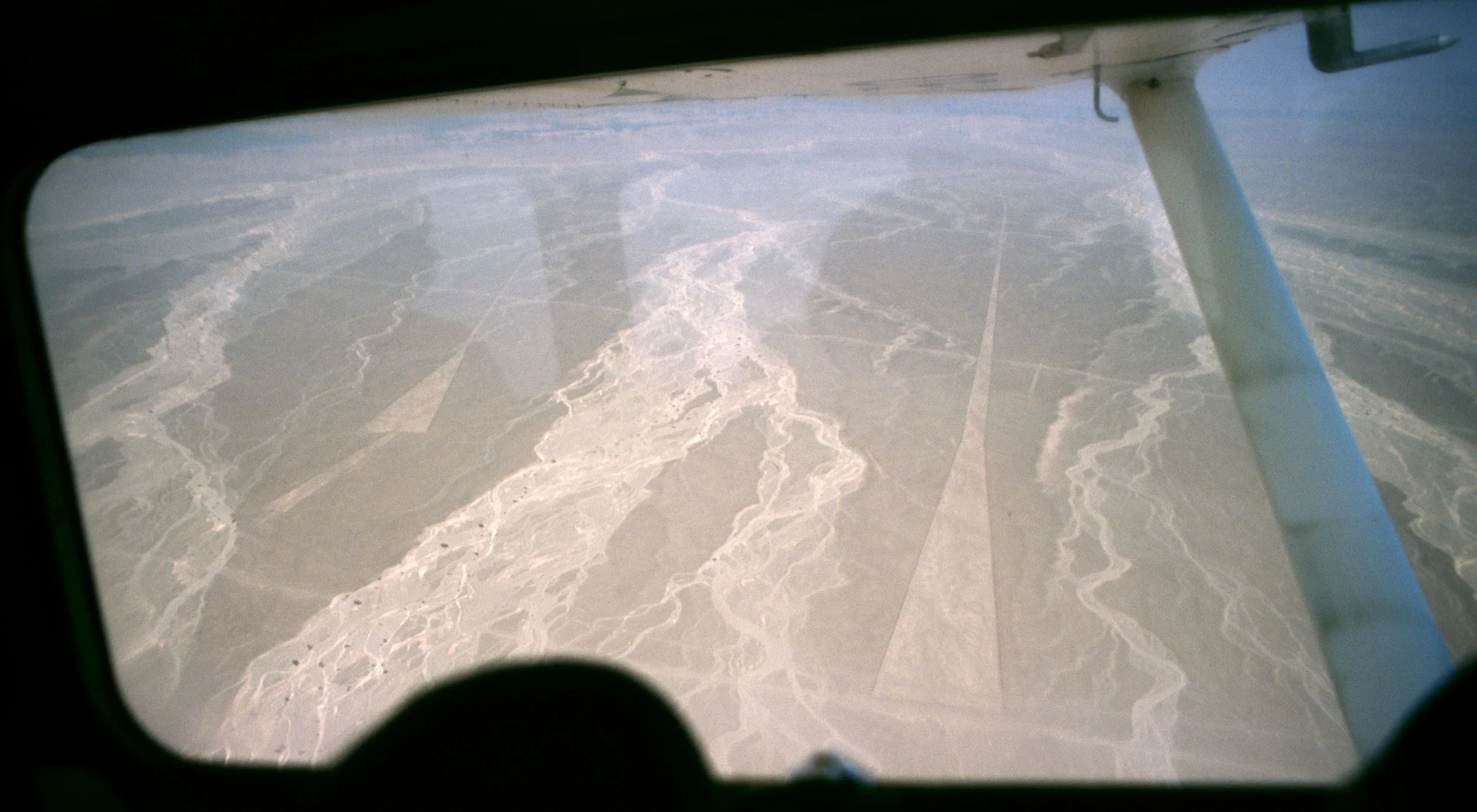
"Landing strip"
The Nazca Lines
I. Introduction: The Mystery Etched into the Earth
Stretching across a desert plateau in southern Peru, these immense geoglyphs form one of humanity’s most enigmatic artistic and engineering achievements. Created more than a thousand years ago, they consist of hundreds of lines, geometric forms, and stylised depictions of animals and plants, some extending for kilometers. Despite decades of research, the full purpose and meaning behind them remain uncertain, positioning the site at the intersection of science, mystery, and cultural imagination.
The lines lie within the remote Nazca Desert, an environment so dry and windless that the surface has remained largely undisturbed for centuries. This stark landscape, composed of iron-oxide-coated stones overlaying pale soil, provided the perfect natural canvas. By simply removing the darker stones, ancient builders exposed lighter earth beneath, producing crisp, high-contrast figures visible across great distances. The region’s extreme aridity—among the driest climates on Earth—has preserved these markings with remarkable clarity, allowing modern observers to witness them almost exactly as their creators intended.
What strikes viewers first is the sheer scale and precision of the designs. Many of the figures are so large that their shapes cannot be recognised from ground level. Only when seen from above—whether from surrounding hills, aircraft, or satellite imagery—do the lines resolve into coherent forms: a hummingbird with wings outstretched, a spiralling monkey tail, a perfectly straight line stretching toward the horizon. This aerial legibility raises immediate questions about how and why such massive compositions were planned and executed by a culture without known flight technology. The geometric accuracy of certain lines, some extending for kilometres without deviation, suggests sophisticated surveying methods and careful communal coordination.
The enduring fascination of the Nazca Lines lies precisely in this blend of clarity and mystery. They are undeniably real, measurable, and human-made, yet their meaning is still debated. Archaeologists investigate them as ritual landscapes, historians study them as cultural expressions, engineers admire their precision, and artists draw inspiration from their minimalist grandeur. At the same time, their monumental scale and apparent invisibility from ground level have fuelled speculation ranging from astronomical alignments to symbolic pathways and even fantastical theories about extraterrestrial involvement. This spectrum of interpretations ensures that the Nazca Lines remain not merely an archaeological site, but a continuing intellectual puzzle—one that invites each generation to reconsider what ancient civilisations were capable of imagining and achieving.
II. Geographic and Environmental Context
Understanding the physical environment in which the Nazca Desert exists is essential to grasping how the geoglyphs survived for centuries with such extraordinary clarity. The landscape of southern Peru is not merely a backdrop for the lines; it is an active participant in their preservation. Every aspect of the terrain—from climate and soil chemistry to atmospheric stability—has contributed to creating one of the most naturally protected archaeological canvases on Earth.
The Nazca region is among the driest places on the planet, receiving only trace amounts of rainfall each year. Some areas may go decades without measurable precipitation. This extreme aridity is not incidental; it is the single most important factor explaining why the geoglyphs have endured for over a millennium. In wetter climates, erosion, vegetation growth, and soil displacement would have obliterated such shallow surface markings long ago. Here, however, the absence of moisture means there is virtually no organic activity to disturb the ground. Bacteria, roots, and burrowing animals—all typical agents of soil disruption—are scarce or absent. As a result, the desert floor remains almost frozen in time, preserving even delicate lines etched only a few centimetres deep.
The stability of this environment also minimizes chemical weathering. Without water to dissolve minerals or transport sediments, the surface layer changes at an exceptionally slow rate. This allows archaeologists today to observe the geoglyphs in conditions strikingly similar to those experienced by their original creators centuries ago.
The visual impact of the Nazca Lines depends on a simple yet effective natural contrast. The desert surface is covered with small stones darkened by a thin coating of iron and manganese oxides, formed through prolonged exposure to sun and air. Beneath this layer lies a much lighter-coloured soil composed primarily of sand and clay. When ancient builders removed the dark stones, they revealed the pale ground underneath, instantly creating a visible line or shape without adding any foreign material.
This geological arrangement functions like a ready-made drawing surface. Instead of painting pigment onto a canvas, the Nazca people effectively erased darkness to expose light. The contrast is so strong that the figures remain visible from high altitudes, especially under the intense sunlight typical of the region. Importantly, once the stones were displaced, they were often placed along the edges of the lines, forming low borders that further defined and protected the shapes.
Deserts are often imagined as windswept environments, but the Nazca plateau is unusually calm. Local atmospheric conditions produce only light winds for most of the year, insufficient to move the heavier surface stones. This lack of strong airflow prevents sand from drifting across the lines and filling them in. Combined with the near-total absence of rainfall, it means that neither water erosion nor wind erosion significantly alters the terrain.
Vegetation is likewise extremely sparse. Plants require moisture to germinate and grow, and in this region water is so scarce that only isolated hardy species survive. Without roots to break apart soil layers or obscure the surface, the geoglyphs remain unobstructed. This rare combination of environmental factors—dryness, stillness, and sterility—has effectively turned the desert into a natural open-air archive.
The Nazca Lines are not only a product of human ingenuity but also of environmental fortune. Their survival is inseparable from the unique geographic and climatic conditions of the Nazca Desert. Without this extraordinary natural setting, one of humanity’s most remarkable large-scale artworks would almost certainly have vanished long before modern science had the chance to study it.
III. Historical Discovery and Study
The modern understanding of the Nazca geoglyphs did not emerge all at once but developed gradually through local knowledge, early scholarly curiosity, and decades of dedicated research. What is often portrayed as a dramatic “discovery” was in reality a layered process in which Indigenous familiarity, colonial observation, and twentieth-century scientific investigation each played essential roles. The story of how the lines came to global attention is itself a fascinating chapter in the history of archaeology.
Long before scholars documented them, the immense ground drawings were known to the people who lived in and around the desert plateau. Local communities traversed the region for generations, and while many of the figures are best appreciated from above, numerous straight lines and geometric shapes are visible from nearby hills or elevated terrain. Oral traditions suggest that inhabitants regarded them not as mysterious anomalies but as part of the cultural landscape—features whose meaning may have been understood symbolically, ritually, or historically within local worldviews.
This early awareness is significant because it challenges the popular narrative that the geoglyphs were “lost” until modern times. Rather than being forgotten, they were simply not studied systematically by outside scholars until the twentieth century.
Spanish chroniclers traveling through southern Peru during the colonial period occasionally described unusual markings or “roads” etched into the desert surface. These references were brief and often misunderstood, as observers lacked the aerial perspective needed to recognize the shapes’ full forms. To travellers on foot or horseback, many of the lines appeared as simple tracks or pathways rather than deliberate artistic designs. As a result, the reports attracted little sustained attention and were rarely followed up with formal investigation.
The first serious academic attention came in the 1920s when Toribio Mejía Xesspe, a Peruvian archaeologist, observed the lines while hiking in the foothills bordering the desert. From elevated vantage points, he realized that the markings were not random but formed intentional patterns. He presented his observations at a scientific conference in 1939, bringing the phenomenon to the awareness of the scholarly world. Although his work did not yet fully document the site, it marked the transition from local curiosity to academic subject.
The American historian Paul Kosok expanded upon Mejía Xesspe’s observations during the late 1930s. Flying over the region in small aircraft, Kosok was among the first researchers to appreciate the full scale and complexity of the designs. He photographed numerous figures and proposed that some lines might align with astronomical events, such as solstices. Although later research would debate these interpretations, Kosok’s aerial surveys were groundbreaking because they demonstrated conclusively that the geoglyphs formed a vast, coordinated system rather than isolated markings.
Perhaps no individual is more closely associated with the study and preservation of the lines than Maria Reiche, a German-born mathematician and archaeologist who arrived in Peru in the 1930s. After collaborating with Kosok, she devoted the rest of her life to documenting, measuring, and protecting the site. Reiche painstakingly mapped figures using simple tools, often working alone in harsh desert conditions. She also became a passionate advocate for preservation, warning authorities about threats from vehicles, construction, and tourism. Through lectures, publications, and public outreach, she helped transform the lines from a little-known curiosity into an internationally recognized cultural treasure.
The global importance of the geoglyphs was formally acknowledged when UNESCO designated them a World Heritage Site in 1994. This status recognised not only their artistic and archaeological value but also their uniqueness as one of the largest known examples of ancient land art. The designation affirmed that the site belongs not just to Peru but to humanity as a whole, deserving international protection and study.
World Heritage recognition brought stricter legal safeguards and conservation measures. Protective zones were established to restrict vehicle access, aerial monitoring programs were implemented to detect damage, and research activities became more regulated. Educational initiatives were also introduced to inform visitors about responsible tourism and the fragility of the site. These policies aim to balance public interest with preservation, ensuring that the lines remain intact for future generations.
The historical study of the Nazca geoglyphs reveals a progression from local knowledge to global recognition. Each stage—Indigenous familiarity, early scholarly observation, systematic scientific research, and international protection—has contributed to our current understanding. The lines are not merely ancient artworks; they are also a testament to decades of human curiosity and dedication, showing how persistent inquiry can gradually illuminate even the most enigmatic traces of the past.
IV. Physical Description of the Lines
The visual impact of the Nazca Lines derives not only from their age and mystery but from their astonishing physical characteristics. Spread across a desert plateau in southern Peru, these immense ground drawings form one of the largest coordinated artistic landscapes ever created. Their sheer size, diversity of forms, and technical precision reveal a sophisticated understanding of spatial planning and collective labor. Examining their physical properties provides essential clues about the people who designed and constructed them, as well as the methods they employed to achieve such monumental results.
The geoglyphs occupy an area of roughly 450 square kilometers across the coastal desert plain. Rather than being clustered in a single location, they are distributed across multiple plateaus separated by shallow valleys. This wide dispersal suggests that the lines were not produced during a single construction phase but accumulated gradually over generations. The landscape functions almost like a vast ceremonial canvas onto which different communities contributed designs at different times.
Their placement also reflects careful site selection. Many figures are positioned on flat surfaces where they can be seen clearly from nearby foothills, while others stretch across open plains where the horizon emphasises their length. This strategic distribution indicates that the creators were attentive to visibility and terrain, choosing locations that enhanced the visual effect of each figure.
Individual lines vary enormously in size. Some are only a few meters long, resembling short marks etched into the surface. Others extend for kilometres in nearly perfect straight trajectories, maintaining consistent width and alignment across uneven terrain. Certain animal figures measure more than a hundred meters from end to end, making them comparable in size to modern sports fields. The scale is so great that a person standing within a design may be unable to perceive its shape at all, experiencing it instead as a simple trench or boundary line. Only from elevated viewpoints—or from the air—does the full image emerge.
The most numerous features are straight lines that traverse the desert floor in parallel sets, radiating patterns, or long solitary paths. Many of these lines appear to converge toward distant points on the horizon, creating visual perspectives that draw the eye across the landscape. Alongside them are geometric shapes such as rectangles, triangles, and trapezoids, some filled with cleared surfaces and others outlined with stone borders. These geometric figures demonstrate remarkable precision, suggesting that their makers understood basic principles of measurement and alignment.
Among the most famous designs are stylised representations of living creatures, often called biomorphs. These include birds with elongated wings, monkeys with spiralling tails, spiders with delicately rendered legs, and fish or whale-like shapes. Plant motifs also appear, though less frequently. The figures are typically drawn in a single continuous line that outlines the subject without shading or internal detail, giving them a strikingly minimalist aesthetic. Despite this simplicity, they remain instantly recognisable, testifying to the artists’ ability to capture essential forms with elegant efficiency.
In addition to straight lines and animal figures, the Nazca landscape contains intricate designs such as spirals, zigzags, and labyrinthine shapes. Spirals are particularly notable because they contrast with the dominant linear geometry, introducing motion and curvature into an otherwise rectilinear environment. Trapezoids—broad shapes that widen at one end—are also common and sometimes extend for hundreds of meters. These varied patterns suggest that the geoglyphs were not created according to a single rigid template but reflect a rich visual vocabulary that evolved over time.
The method used to create the lines was deceptively simple. The desert surface is covered with small stones darkened by oxidation, while lighter-coloured soil lies beneath. By removing the dark stones and pushing them aside, builders exposed the pale ground, forming visible lines that contrasted sharply with the surrounding terrain. The displaced stones were often piled along the edges of the cleared paths, reinforcing the outlines and helping protect them from disturbance.
This technique required no complex tools or imported materials, only careful labor and planning. Yet the results are durable enough to last for centuries, demonstrating how effective the method was within the region’s stable environment.
Archaeological evidence indicates that the Nazca people used basic surveying tools such as wooden stakes and cords to guide their work. Researchers have discovered stake holes at some sites, suggesting that builders marked reference points before clearing the lines. By stretching ropes between stakes, they could maintain straight trajectories over long distances and reproduce consistent widths. This approach would have allowed teams of workers to execute designs accurately even when they could not see the entire figure from ground level.
Certain geoglyphs display proportions and alignments that imply careful preplanning. Some scholars propose that designers used grid systems or scaled drawings to translate small designs into large ground versions. For example, a small sketch might have been divided into sections, each corresponding to a larger area marked out on the desert floor. Evidence for such planning can be seen in the symmetry of certain figures and the parallel spacing of lines across wide areas. While the exact methods remain debated, the precision visible in many designs indicates that the builders employed systematic measurement techniques rather than improvisation.
The physical characteristics of the Nazca Lines reveal a remarkable fusion of simplicity and sophistication. The materials were basic, the tools minimal, and the environment harsh—yet the results are vast, precise, and enduring. These features underscore not only the technical ingenuity of their creators but also their ability to envision artworks on a scale rarely attempted in human history.
V. Iconography and Symbolism
The imagery carved into the desert surface of the Nazca Lines is not random decoration but a carefully selected symbolic vocabulary. The figures, shapes, and orientations appear to reflect a worldview in which landscape, cosmology, ritual practice, and artistic expression were deeply intertwined. Although scholars continue to debate precise meanings, the recurring motifs provide valuable insight into the beliefs and priorities of the culture that created them.
Among the most striking geoglyphs are stylised representations of animals. Some of the best-known examples include a long-winged hummingbird, a spiral-tailed monkey, a delicate spider, a soaring condor, a whale-like marine figure, and a dog-shaped outline. Each is rendered in a continuous line that captures essential anatomical features with remarkable economy. The hummingbird’s needle-like beak, for instance, is exaggerated into a long, precise stroke, while the monkey’s curled tail becomes a bold spiral that dominates the composition.
The selection of species is unlikely to be arbitrary. Many depicted animals held symbolic importance in ancient Andean cultures. Birds often represented messengers between earthly and celestial realms; spiders were associated with rain and fertility; marine animals may have symbolised the ocean’s life-giving power. The recurrence of such creatures suggests that the geoglyphs formed part of a symbolic system understood by the people who created and used them.
Interpretations of these figures frequently draw on comparative anthropology and archaeological evidence from ceramics and textiles of the same culture. In these artefacts, animals appear as mythological beings, protective spirits, or ritual symbols. The geoglyphs may therefore represent deities, mythic ancestors, or spiritual intermediaries. Some scholars propose that certain figures functioned as offerings or invocations intended to communicate with supernatural forces governing rain, crops, and survival in the harsh desert environment.
Beyond animal imagery, the desert is filled with straight lines and geometric shapes that stretch across the plateau. Many of these lines appear to align with prominent features of the surrounding landscape, such as distant mountains or valleys. In some cases, they seem to point toward areas where underground water sources are known to exist. These alignments have led researchers to propose that the lines functioned as directional markers, linking sacred geography with human ritual space.
Other studies have examined possible astronomical alignments. Certain lines correspond roughly to the rising or setting points of the sun during solstices or equinoxes, though such correlations remain debated. Even when exact celestial precision is uncertain, the possibility that the lines were oriented toward sky events suggests a worldview in which terrestrial and cosmic realms were symbolically connected.
One widely discussed interpretation holds that at least some lines were intended to be walked. Their widths are often consistent and their surfaces cleared smooth, making them suitable for processions. Archaeologists have found evidence of footprints and small offerings along certain lines, supporting the idea that they served as ceremonial pathways. In this interpretation, participants may have followed the lines during rituals, tracing sacred routes across the desert as acts of devotion, prayer, or communal identity.
The geoglyphs are attributed to the Nazca culture, which flourished in southern Peru between roughly 200 BCE and 600 CE. Archaeological discoveries from settlements, burial sites, and artifacts show that this society possessed advanced artistic traditions, complex religious practices, and sophisticated environmental knowledge. The same visual motifs seen in the desert lines also appear in pottery designs and textile patterns, indicating that the geoglyphs were part of a broader symbolic language rather than an isolated artistic experiment.
Life in an extremely arid region shaped the spiritual outlook of the Nazca people. Water was not merely a resource but a sacred force essential for survival. Many scholars believe the geoglyphs were linked to rituals intended to ensure rainfall, agricultural fertility, and ecological balance. Mountains, clouds, animals, and underground water sources likely held spiritual significance as manifestations of divine power.
Within this worldview, the desert itself may have been understood as a sacred stage where humans could communicate with supernatural forces. By inscribing enormous figures onto the land, the Nazca transformed the environment into a symbolic canvas visible to gods, spirits, or celestial beings. The lines thus functioned simultaneously as art, ritual space, and cosmological expression.
The iconography of the Nazca Lines reveals a culture that expressed its beliefs not through written language but through monumental imagery embedded in the earth itself. The animals, geometric forms, and alignments form a visual theology—one that continues to intrigue scholars because it speaks in symbols rather than words, inviting interpretation while preserving its deepest meanings.
VI. The Nazca Civilization Behind the Lines
To understand the monumental geoglyphs etched into the desert plains, one must first understand the people who created them. The society responsible for these works flourished for centuries along the southern coast of what is now Peru, developing a culture uniquely adapted to one of the harshest environments on Earth. Far from being a primitive or isolated community, the Nazca civilisation demonstrated remarkable ingenuity in agriculture, engineering, religious expression, and artistic production. Their achievements suggest a complex social structure capable of organising labor, sustaining trade, and maintaining shared symbolic traditions.
Life in the Nazca region required constant negotiation with the desert environment. Rainfall was scarce and unpredictable, yet the population managed to cultivate crops such as maize, beans, squash, and cotton. This success was possible because the Nazca people understood their landscape intimately. They selected fertile valleys where seasonal rivers occasionally flowed and practiced methods of soil conservation to maximize productivity. Farming was not merely subsistence work; it formed the economic foundation that supported artisans, ritual specialists, and community leaders.
Agricultural production also shaped social organisation. Coordinating planting and harvesting cycles required communal cooperation, and surplus food likely played a role in ceremonial gatherings and exchanges between settlements.
Among the most impressive achievements of the Nazca were their underground irrigation systems, known today as puquios. These carefully engineered channels tapped into subterranean aquifers and transported water across long distances to fields and villages. Many puquios were constructed with spiral access shafts, allowing maintenance workers to descend and clear debris. The design not only provided a reliable water supply but also protected the channels from evaporation under the intense desert sun.
Some of these systems remain functional today, demonstrating the durability of their engineering. Their existence reveals that the Nazca were skilled hydrologists who understood groundwater behavior and could manipulate it to sustain agriculture in an otherwise inhospitable environment.
The Nazca were not isolated. Archaeological evidence indicates that they participated in regional trade networks connecting coastal, highland, and jungle regions. Goods such as obsidian, feathers, shells, and exotic pigments traveled across long distances, suggesting established exchange routes and diplomatic relationships with neighbouring cultures. These interactions facilitated not only commerce but also the spread of artistic styles and religious ideas, enriching Nazca culture and linking it to broader Andean traditions.
Religion occupied a central place in Nazca society. Ritual specialists—often described as shamans by modern scholars—likely acted as intermediaries between human communities and the spiritual forces believed to govern nature. Ceremonies may have included music, dance, offerings, and processions, possibly conducted along some of the geoglyph lines themselves. Such rituals would have reinforced social cohesion while reaffirming the community’s relationship with supernatural powers.
Iconography found in burial goods suggests that these spiritual leaders held significant authority. They may have directed large communal projects, including the creation of the desert figures, which would have required coordination, planning, and shared belief in their purpose.
Nazca artistic traditions are renowned for their vivid colours and intricate designs. Pottery vessels display stylized animals, mythical beings, and geometric patterns remarkably similar to those seen in the desert geoglyphs. Textiles likewise feature repeating motifs and symbolic imagery, often executed with extraordinary technical skill. These parallels indicate that the same symbolic language permeated multiple forms of expression—from portable objects to monumental land art.
Such consistency suggests that Nazca art was not merely decorative but communicative, conveying mythological narratives, social identity, and spiritual meaning. The geoglyphs can therefore be viewed as the largest-scale manifestation of an artistic system that also existed in miniature.
Like many ancient societies, the Nazca civilisation eventually declined. One leading explanation points to environmental degradation. Archaeological studies suggest that extensive cutting of native trees—particularly the huarango, which stabilised soil and retained moisture—may have contributed to erosion and reduced agricultural productivity. Without these natural safeguards, fertile land could have deteriorated, undermining the food supply and straining social stability.
Climatic fluctuations may have compounded these problems. Periods of severe drought followed by catastrophic flooding—possibly linked to recurring El Niño events—would have disrupted farming cycles and damaged infrastructure. Such instability can weaken centralised authority and trigger migration or conflict. Over time, these pressures likely led to the fragmentation of Nazca society, with communities dispersing or merging into emerging regional cultures.
The story of the Nazca civilisation is one of ingenuity, adaptation, and resilience, but also of vulnerability to environmental change. Their irrigation works, artistic achievements, and monumental geoglyphs testify to a society capable of extraordinary coordination and vision. At the same time, their eventual decline illustrates how closely human cultures are tied to ecological balance. The lines they left behind endure as silent witnesses to both their brilliance and their fragility, preserving the memory of a people who transformed a desert into a canvas of belief and identity.
VII. Scientific Theories About Purpose
Few archaeological sites have inspired as many competing interpretations as the Nazca Lines. Because the creators left no written explanation, scholars must infer purpose from physical evidence, cultural context, and comparative analysis. Over decades of research, several major scientific theories have emerged. None alone explains every feature, and many researchers believe the lines may have served multiple functions simultaneously. The following interpretations represent the most widely discussed scholarly perspectives.
One of the earliest scholarly explanations proposed that some lines align with astronomical phenomena such as solstices, equinoxes, or the rising and setting positions of prominent stars. Researchers observed that certain straight lines appear to point toward points on the horizon where the sun rises or sets at specific times of year. Because ancient agricultural societies often relied on celestial observation to track seasonal cycles, it seemed plausible that the lines functioned as large-scale calendars or astronomical markers.
Some investigators also suggested correlations between particular animal figures and constellations. For instance, bird shapes were compared to star patterns, and geometric lines were interpreted as sight lines for observing celestial events. Such interpretations framed the desert plateau as a kind of observational instrument embedded in the landscape.
While intriguing, the astronomical hypothesis has been heavily debated. Critics point out that with hundreds of lines oriented in many directions, some alignments with celestial points could occur by chance. Statistical studies have shown that not all lines correspond meaningfully to astronomical positions, and many appear unrelated to solar or stellar events. Modern archaeologists therefore tend to treat astronomical alignment as a possible feature of some lines rather than a universal explanation. The current scholarly consensus suggests that astronomy may have played a role in certain cases but cannot account for the entire complex.
Another influential interpretation proposes that at least some lines were intended to be walked. Their widths are often consistent, their surfaces cleared smooth, and their trajectories carefully maintained across long distances—all characteristics compatible with processional pathways. In this view, the geoglyphs formed part of ritual performances in which participants moved along designated routes, perhaps singing, praying, or carrying offerings. The act of walking the lines may itself have been symbolic, representing journeys, pilgrimages, or communication with the spiritual realm.
This interpretation also explains why many lines do not form recognisable images from ground level. If their purpose was experiential rather than visual, their meaning would lie in movement along them rather than observation from above.
Support for this theory comes from physical traces discovered along certain lines. Archaeologists have identified footprints, compacted soil, and fragments of offerings such as pottery shards or organic materials. These findings suggest repeated human activity rather than one-time construction. In addition, some lines lead toward natural features such as hills or water sources, which may have been considered sacred destinations within ritual landscapes.
Given the extreme dryness of the Nazca region, many scholars interpret the geoglyphs as part of a ritual system centred on water and fertility. In this view, the lines functioned as symbolic appeals to supernatural forces believed to control rainfall and agricultural productivity. Animal figures such as birds or amphibians—often associated in Andean cosmology with rain or clouds—may have been intended as visual invocations or offerings inscribed directly into the earth.
The immense scale of the figures would have amplified their symbolic power. Creating them required collective effort, which could itself be understood as a communal act of devotion intended to secure divine favor.
Some researchers have noted correlations between certain lines and the locations of subterranean water channels. This observation has led to the suggestion that the geoglyphs might mark or honor underground aquifers essential for survival. The desert landscape contains ancient irrigation systems that tap into hidden water sources, and the lines may have served as ritual markers acknowledging these life-giving reserves. In this interpretation, the geoglyphs represent a sacred geography mapping the relationship between people, land, and water.
Beyond spiritual interpretations, some scholars emphasise the social dimension of constructing the lines. Creating large geoglyphs required coordinated labor, planning, and leadership. Organising such projects could have strengthened social bonds, reinforced community identity, and demonstrated the authority of leaders or ritual specialists. From this perspective, the lines were not only symbolic images but also instruments of social cohesion—visible proof that a community could work together toward a shared goal.
Another possibility is that certain geoglyphs functioned as territorial markers or expressions of group identity. Different communities might have created distinct figures or line systems to assert presence within the landscape. Rather than marking political borders in a modern sense, these designs could have signalled cultural affiliation or ritual ownership of particular areas. Such interpretations align with evidence from other ancient societies in which large landscape features served to express identity and collective memory.
The scientific theories about the purpose of the Nazca Lines reveal a complex picture rather than a single definitive answer. Astronomical observation, ritual movement, ecological symbolism, and social organisation may all have contributed to their creation. The diversity of explanations underscores the richness of the Nazca cultural imagination and reminds us that ancient monuments often served multiple roles at once—practical, spiritual, communal, and symbolic.
VIII. Fringe and Popular Theories
The immense scale and unusual visibility of the Nazca Lines have not only inspired scientific research but also fuelled a wide range of speculative interpretations. While archaeologists base conclusions on material evidence, environmental context, and cultural parallels, popular imagination has often ventured into more sensational territory. These fringe theories, though lacking scholarly support, have played a significant role in shaping public perception of the site and continue to circulate widely in books, television, and online media.
One of the most famous alternative explanations proposes that the geoglyphs were created with assistance from extraterrestrial visitors. This idea gained global attention through the writings of Erich von Daniken, a Swiss author whose books argued that ancient monuments around the world show evidence of alien influence. He suggested that the long straight lines resembled runways for spacecraft and that the enormous animal figures were signals or messages intended for beings observing from the sky.
Such claims captured the public imagination because they seemed to offer a dramatic solution to a genuine mystery: how ancient people could design and construct enormous images best appreciated from above. The extraterrestrial hypothesis quickly became one of the most widely recognised popular explanations for the lines, especially through translations, documentaries, and television programs.
Despite its popularity, the extraterrestrial theory is rejected by archaeologists, historians, and other scientists. The primary reason is that no physical evidence supports it. Excavations and surveys have uncovered tools, stakes, pathways, and other signs of human construction consistent with known Nazca technologies. The methods required to produce the lines—clearing stones, measuring distances, and coordinating labor—are entirely achievable using simple tools and organised human effort.
Moreover, archaeological research demonstrates continuity between the geoglyphs and other forms of Nazca art, such as pottery and textiles, which feature the same motifs and stylistic conventions. This cultural continuity strongly indicates that the lines are products of the Nazca civilisation itself rather than the work of external visitors. From a scientific standpoint, extraordinary claims require extraordinary evidence, and such evidence has never been found.
Television specials, speculative books, and internet videos have played a major role in spreading sensational interpretations of the lines. Programs focusing on unexplained mysteries often highlight dramatic possibilities—ancient astronauts, lost technologies, or hidden civilisations—because such narratives attract viewers. The visual spectacle of the desert figures, combined with their mysterious origin, makes them especially appealing subjects for this style of storytelling.
Popular culture has reinforced these ideas through fiction, films, and graphic media that portray the lines as coded messages, landing strips, or cosmic symbols. While entertaining, these portrayals frequently blur the distinction between imaginative speculation and scholarly research, leading audiences to assume that fringe theories hold equal weight with evidence-based conclusions.
Scholars emphasise the importance of evaluating claims according to empirical evidence rather than dramatic appeal. Scientific investigation relies on measurable data, reproducible analysis, and peer review, whereas fringe theories often depend on selective observations or assumptions that cannot be tested. Learning to distinguish between these approaches is essential not only for understanding the Nazca Lines but also for interpreting archaeological discoveries in general.
Recognising the difference does not diminish the wonder of the site. On the contrary, the verified achievements of the Nazca people—their engineering skill, artistic vision, and environmental knowledge—are arguably more impressive than speculative alternatives. The real story, grounded in human ingenuity and cultural creativity, demonstrates that ancient societies were capable of extraordinary accomplishments without the need for supernatural or extraterrestrial intervention.
In the end, fringe and popular theories reveal as much about modern curiosity as they do about the ancient past. They show how mystery invites imagination, especially when confronted with monuments that challenge expectations. Yet they also highlight the value of disciplined inquiry, reminding us that careful study, rather than sensational speculation, offers the most reliable path to understanding one of humanity’s most remarkable archaeological legacies.
IX. Modern Research Technologies
The study of the Nazca Lines has entered a new era in recent decades, driven by rapid advances in imaging technology, computational analysis, and archaeological methodology. Where early researchers relied on ground observations and occasional flights, modern scientists now employ tools capable of detecting subtle patterns invisible to the naked eye. These innovations are transforming understanding of the site, revealing previously unknown figures, refining measurements, and helping preserve the fragile desert landscape while minimising physical disturbance.
Unmanned aerial vehicles—commonly known as drones—have revolutionised archaeological documentation. Equipped with high-resolution cameras and GPS positioning systems, drones can capture detailed images of geoglyphs from multiple angles and altitudes. These images can then be stitched together to produce precise digital maps accurate to within centimetres. Researchers can analyse line widths, angles, and spatial relationships without stepping directly on the figures, reducing the risk of damage.
The ability to conduct repeated aerial surveys also allows scientists to monitor subtle changes over time. By comparing datasets collected months or years apart, they can detect erosion, human interference, or environmental shifts that might threaten preservation.
Satellite imagery has expanded the search beyond areas easily accessible on foot or by vehicle. High-resolution satellite photographs reveal faint outlines and patterns that might otherwise blend into the surrounding terrain. In several instances, researchers examining satellite data have identified new geoglyphs that were previously undocumented. Some of these figures are smaller or more eroded than the well-known designs, suggesting that the Nazca landscape contains far more imagery than originally believed.
Such discoveries demonstrate that the desert plateau still holds secrets waiting to be uncovered. As imaging technology improves, archaeologists anticipate that additional figures—especially those partially buried or weathered—may be detected.
Modern research increasingly incorporates computational methods capable of analysing vast quantities of visual data. Pattern-recognition algorithms can scan aerial or satellite imagery to identify shapes resembling known geoglyph forms. These systems can highlight subtle contrasts or geometric arrangements that human observers might overlook, especially across large areas.
By training algorithms on verified examples of Nazca figures, researchers can teach computers to recognise characteristic line structures, curvature patterns, and proportions. This approach accelerates the process of locating new geoglyphs and reduces the chance of missing faint or incomplete designs.
Artificial intelligence tools also enable predictive modelling. Using environmental data, topography, and known geoglyph locations, researchers can generate probability maps indicating where undiscovered figures are most likely to be found. These models guide field expeditions toward promising sites, saving time and resources while increasing the likelihood of success.
Such predictive methods represent a shift from purely exploratory archaeology to hypothesis-driven investigation supported by data analytics. In effect, computers help archaeologists “see” patterns in the landscape before they are physically verified.
Preserving the fragile desert surface is a top priority, so modern archaeologists favor non-invasive techniques whenever possible. Ground-penetrating radar, magnetometry, and photogrammetry allow researchers to study subsurface features and structural variations without excavation. These tools can reveal buried lines, hidden pathways, or ancient construction marks while leaving the site undisturbed.
Laser scanning technology, including LiDAR, can also produce highly detailed three-dimensional models of the terrain. Such models help researchers analyse elevation differences and subtle surface textures that may indicate previously unrecognised designs.
Scientific analysis of soil samples and surface stones provides insight into construction methods and environmental history. By examining mineral composition, researchers can determine how the ground has changed over time and whether particular lines have been altered or restored. Microscopic studies of soil layers may also reveal traces of human activity, such as footprints or tool marks, offering clues about how the geoglyphs were made.
Chemical analysis can even detect residues from organic materials once deposited as offerings, shedding light on ritual practices associated with the lines. These laboratory techniques transform seemingly simple desert soil into a record of ancient behavior and environmental conditions.
Modern research technologies have fundamentally reshaped the study of the Nazca Lines. What was once an enigmatic set of shapes glimpsed from airplanes is now a richly documented archaeological landscape analysed through drones, satellites, sensors, and algorithms. Each new technological advance deepens understanding while reinforcing an important lesson: the mysteries of the past often yield their secrets not through speculation, but through careful observation enhanced by the best tools of the present.
X. Preservation Challenges
The continued survival of the Nazca Lines is not guaranteed. Although the arid plateau of southern Peru preserved these immense geoglyphs for centuries, modern pressures—both human and natural—now threaten their fragile integrity. Unlike stone monuments or buried ruins, the lines consist of shallow surface markings that can be damaged easily and permanently. Understanding these risks is essential for ensuring that this extraordinary archaeological landscape endures for future generations.
Growing global interest in the site has brought increasing numbers of visitors. While tourism helps support local economies and raises awareness of cultural heritage, it also poses risks. The desert surface is extremely delicate; even a single set of footprints can disturb the contrast between dark stones and light soil that defines the figures. Vehicles are especially destructive. Tire tracks can cut across lines in seconds, leaving scars that may remain visible for decades or longer.
Several incidents over recent years have demonstrated how vulnerable the geoglyphs are to accidental or unauthorised access. Because the lines are so large, visitors on the ground may not realize they are standing within a figure. This makes strict access controls and clear visitor guidelines essential.
Development pressures present another challenge. As nearby towns grow and transportation networks expand, roads, power lines, and construction projects risk encroaching on protected areas. Even when development occurs outside the main zone, associated activities such as construction traffic or land clearing can disturb the surrounding landscape and indirectly affect the geoglyphs. Balancing economic growth with cultural preservation remains an ongoing challenge for regional authorities.
Although the region is typically dry, periodic climatic phenomena can bring sudden rainfall. Strong El Niño events sometimes produce intense downpours that cause flash floods across normally dry terrain. When water flows across the desert surface, it can wash away stones that define the lines or deposit sediment that obscures them. Because the geoglyphs are shallow, even small amounts of erosion can alter their shape.
Climate variability raises concerns that such extreme weather events could become more frequent or intense, increasing the risk of long-term damage.
Wind is usually gentle in the Nazca region, but occasional storms can still move sand and dust across the plateau. Over time, drifting particles may accumulate within the cleared lines, gradually reducing their visibility. Erosion can also soften edges, blurring once-sharp outlines. Although these processes occur slowly, their cumulative effect across decades or centuries can significantly change the appearance of the figures.
To safeguard the geoglyphs, authorities and researchers have implemented protective measures. Restricted zones limit vehicle access, and observation towers allow visitors to view selected figures without walking on them. Surveillance systems and aerial monitoring help detect unauthorized entry or new damage quickly, enabling rapid response and repair when possible.
International cooperation has also played a role. The site’s recognition by UNESCO as a World Heritage Site brought global attention and support, encouraging stricter preservation policies and providing resources for conservation projects.
Long-term protection depends not only on regulations but also on public understanding. Educational programs inform local residents, guides, and visitors about the cultural importance and fragility of the lines. When communities recognise the site as part of their shared heritage, they are more likely to support preservation efforts and discourage harmful activities.
Schools, museums, and outreach campaigns often emphasise the historical and scientific value of the geoglyphs, fostering a sense of stewardship. This community-based approach is crucial because sustainable preservation ultimately relies on cooperation between authorities, researchers, and the people who live near the site.
The preservation of the Nazca Lines represents a delicate balance between access and protection, development and conservation, curiosity and responsibility. Though the desert once shielded them naturally, the modern world has introduced new vulnerabilities. Safeguarding these ancient designs now requires vigilant management, scientific monitoring, and collective respect—ensuring that one of humanity’s most extraordinary cultural landscapes remains visible across the sands of time.
XI. Cultural Significance and Global Impact
The enduring fascination with the Nazca Lines extends far beyond archaeological circles. These vast desert images have become a cultural emblem, a source of artistic inspiration, and a cornerstone of interdisciplinary research. Their impact reaches across national boundaries, influencing how people understand ancient civilisations, artistic expression, and humanity’s relationship with landscape. The lines are not only remnants of a distant past; they are living symbols that continue to shape identity, creativity, and scientific inquiry in the present.
Within Peru, the Nazca geoglyphs stand as one of the country’s most recognisable cultural icons. They represent the ingenuity of pre-Columbian societies and serve as tangible proof of the sophistication achieved by ancient Andean civilisations long before European contact. For many Peruvians, the lines symbolise continuity between past and present, linking modern national identity to ancestral creativity and resilience.
The imagery of the geoglyphs appears frequently in educational materials, tourism campaigns, and cultural events. Their distinctive forms—especially well-known figures such as birds and geometric shapes—have become visual shorthand for Peru’s ancient heritage, much as pyramids symbolize Egypt or temples represent classical Greece. This symbolic power reinforces a sense of pride in the country’s archaeological legacy.
The lines also play a significant role in Peru’s tourism economy. Visitors from around the world travel to the region to view the figures from observation towers or aerial tours. This influx of travellers supports local businesses, guides, transportation services, and conservation initiatives. Tourism revenue helps fund preservation efforts and archaeological research, creating a feedback loop in which cultural heritage sustains economic development while also requiring careful protection.
Balancing accessibility with preservation is crucial. Authorities must ensure that tourism remains sustainable so that economic benefits do not come at the expense of the fragile desert environment.
The visual simplicity and monumental scale of the Nazca figures have inspired artists across disciplines. Contemporary painters, graphic designers, architects, and digital creators often reinterpret the shapes in new media, transforming ancient motifs into modern artistic language. The clean lines, bold silhouettes, and striking contrasts characteristic of the geoglyphs resonate strongly with modern design aesthetics, particularly minimalist and abstract styles.
These reinterpretations demonstrate how ancient imagery can remain creatively relevant across millennia. By adapting Nazca motifs into contemporary works, artists participate in an ongoing dialogue between past and present, proving that the lines are not static relics but active sources of inspiration.
The Nazca Lines have also influenced large-scale environmental art, especially the twentieth-century land art movement. Artists who create works directly within landscapes—using earth, stone, or natural materials—often cite ancient geoglyphs as precedents for their practice. The idea that the land itself can function as a canvas has deep historical roots, and the Nazca examples show that monumental earth art is not a modern invention but a tradition stretching back centuries.
This connection highlights a broader artistic principle: humans have long sought to shape their environment not only for survival but also for symbolic and aesthetic expression.
For scholars, the Nazca Lines provide a unique case study in how ancient societies organised labor, expressed belief systems, and interacted with their environment. Archaeologists analyze the lines to understand construction techniques and social organisation, while anthropologists interpret them as cultural texts that encode religious symbolism and communal identity. Because the geoglyphs combine artistic, ritual, and environmental elements, they offer rare insight into the integration of multiple aspects of ancient life.
Their study also demonstrates the importance of interdisciplinary research. Understanding the lines requires collaboration among archaeologists, geologists, historians, engineers, and environmental scientists, each contributing expertise to reconstruct the past.
From an engineering perspective, the geoglyphs illustrate how precise large-scale designs can be achieved using simple tools and collective coordination. The straightness of long lines, the symmetry of figures, and the consistency of proportions reveal advanced planning and spatial reasoning. These features challenge assumptions about technological capability in ancient societies and remind modern observers that sophisticated results do not always require complex machinery.
The global significance of the Nazca Lines lies in their ability to transcend time, geography, and discipline. They are simultaneously national symbols, artistic inspirations, and scientific resources. By continuing to captivate audiences worldwide, they demonstrate the enduring power of human creativity expressed on a monumental scale—an achievement that speaks not only to the culture that created them but to the shared heritage of humanity as a whole.
XII. Comparative Context: Other Geoglyph Traditions
The vast figures of the Nazca Lines are often regarded as unique, yet they belong to a broader human tradition of creating monumental images directly on the landscape. Across continents and cultures, societies separated by time and geography have inscribed symbols, animals, and abstract forms into hillsides, deserts, and plains. These works vary widely in scale, style, and meaning, but all demonstrate a shared impulse to transform the earth itself into a medium of expression. Examining comparable geoglyph traditions helps illuminate both the universality of this impulse and the distinctive features that set each tradition apart.
One of the closest parallels to the Nazca figures is the Atacama Giant, located on a hillside in northern Chile’s Atacama Desert. Measuring more than one hundred meters tall, it is the largest known prehistoric anthropomorphic geoglyph in the world. Unlike many Nazca figures, which lie on flat plains, the Atacama Giant is carved into a slope, making it visible from a distance without requiring an aerial perspective.
Scholars believe the figure may have functioned as an astronomical or calendrical marker, possibly related to lunar cycles or seasonal observations. Its geometric headdress and stylised limbs resemble motifs found in regional rock art and textiles, suggesting it was embedded within a broader symbolic system. The construction technique—removing surface stones to expose lighter soil—is similar to that used in Peru, indicating convergent solutions to the challenge of creating durable desert imagery.
In southern England, the Uffington White Horse offers a strikingly different example of large-scale ground imagery. Carved into a grassy hillside during the late Bronze Age or early Iron Age, this stylised horse is formed not by clearing stones but by cutting trenches into turf to reveal the white chalk beneath. The figure’s sweeping curves and minimalist design give it an abstract, almost modern appearance despite its antiquity.
Unlike the Nazca Lines, which are best appreciated from above, the White Horse was intended to be seen from ground level or distant vantage points. It likely held symbolic or territorial significance, perhaps representing a tribal emblem, a mythological creature, or a protective symbol associated with the landscape. Periodic maintenance by local communities over centuries has been essential to keep the figure visible, highlighting a key difference from desert geoglyphs that survive largely through natural preservation.
In the Colorado Desert of the southwestern United States lie the Blythe Intaglios, a group of large ground figures created by Indigenous peoples centuries ago. These designs include human forms, animals, and geometric shapes etched into the desert surface using techniques similar to those employed in Peru—scraping away darker stones to expose lighter soil beneath.
Archaeological interpretation suggests that the figures may have had ceremonial or mythological significance, possibly connected to creation stories or ancestral spirits. Their placement near ancient travel routes hints that they could also have served as ritual landmarks or markers within sacred landscapes. Like the Nazca figures, they are best seen from above, reinforcing the idea that aerial visibility was not always necessary for meaning; symbolic intent may have outweighed practical visibility.
Across these examples, several shared characteristics emerge. All are monumental in scale, requiring planning, coordination, and communal labor. Each uses locally available materials—stones, soil, chalk, or vegetation—to create high-contrast images that can endure over long periods. In all cases, the geoglyphs appear to have held symbolic, ritual, or cultural significance rather than serving purely decorative purposes.
Yet the differences are equally revealing. Environmental context strongly influenced construction methods: desert cultures tended to remove stones to expose lighter ground, while temperate-climate builders carved into turf or hillside soil. Visibility also varied. Some figures were designed for distant viewing from hills or valleys, others for overhead observation, and still others for experiential interaction by people walking near them.
Perhaps most importantly, the meanings attributed to these works differ according to cultural worldview. In some traditions, geoglyphs may have functioned as ritual pathways, in others as territorial emblems or cosmological symbols. These variations show that while the impulse to create land-based imagery is widespread, the purposes behind it are shaped by each society’s beliefs, environment, and social structure.
These global examples demonstrate that the Nazca Lines are part of a much larger human story. They represent one expression of a universal artistic instinct: the desire to leave lasting marks upon the earth that communicate identity, belief, and imagination across generations. By comparing them with other geoglyph traditions, we gain a deeper appreciation not only of their uniqueness but also of their place within humanity’s shared heritage of monumental landscape art.
XIII. Unanswered Questions and Future Research
Despite a century of systematic study, the Nazca Lines remain one of archaeology’s most intriguing enigmas. Modern technology has clarified how they were constructed and identified many aspects of their cultural context, yet several fundamental questions continue to challenge researchers. These unresolved issues are not signs of failure but indicators of how complex the site truly is. Each unanswered question points toward new avenues of investigation and highlights the potential for future discoveries that may reshape our understanding of this ancient landscape.
One of the most persistent mysteries concerns the immense size of the geoglyphs. Many figures span hundreds of meters, dimensions far exceeding what would be necessary for designs intended primarily for ground-level viewing. This raises a central question: why invest enormous effort in creating images whose full shapes are difficult or impossible to perceive from nearby vantage points?
Several explanations have been proposed. Some scholars argue that visibility from above was not the goal; instead, the scale itself may have held symbolic meaning, expressing devotion or power through sheer magnitude. Others suggest that the figures were meant to be seen from surrounding hills rather than directly overhead. In this interpretation, elevated terrain could have served as natural viewing platforms, allowing observers to recognise the designs without requiring flight. Still, the exact relationship between scale, visibility, and meaning remains unresolved, leaving room for continued debate.
Another question that has captured both scholarly and public imagination is whether the creators had ways to observe their designs from above. Archaeologists have identified nearby hills and ridges that provide partial views of some figures, supporting the idea that natural elevations may have been used during planning or ceremonial observation. However, not all geoglyphs are visible from these points, which has led to speculation about artificial platforms or towers that may once have existed but have since eroded or disappeared.
A more controversial idea proposes that the Nazca people might have experimented with simple balloon-like devices made from textiles. While no direct archaeological evidence confirms such technology, the Nazca were skilled textile producers, and some researchers have explored whether lightweight fabrics could theoretically support a hot-air balloon structure. Most scholars remain cautious about this hypothesis, emphasising that it currently rests on conjecture rather than physical proof. Nevertheless, the question illustrates how the site continues to inspire investigation into ancient technological possibilities.
Another frontier of research involves the possibility that many more geoglyphs remain undiscovered. Over centuries, shifting sediments, minor erosion, and environmental changes may have partially buried or obscured older designs. Some recently identified figures were detected only through advanced imaging techniques, suggesting that additional lines may lie concealed beneath thin layers of soil or desert debris.
If such hidden geoglyphs exist, they could significantly alter current interpretations. New discoveries might reveal chronological sequences showing how designs evolved over time, or they might expose entirely different styles indicating multiple cultural phases. Future surveys using remote sensing, subsurface scanning, and machine-learning analysis are expected to play a crucial role in locating these potential buried features.
The remaining mysteries surrounding the Nazca Lines ensure that they will continue to attract scholarly attention. Ongoing projects aim to refine dating methods, analyse soil chemistry, and map the region with ever-increasing precision. Interdisciplinary collaboration is particularly important, combining expertise from archaeology, climatology, engineering, anthropology, and computer science. Such partnerships allow researchers to address questions that no single discipline could resolve alone.
At the same time, preservation concerns shape the future of research. Because the geoglyphs are fragile, investigators must develop techniques that minimize physical impact while maximising data collection. Advances in remote imaging and digital modelling are therefore likely to define the next phase of study, enabling scientists to explore the site in unprecedented detail without disturbing its surface.
The enduring mystery of the Nazca Lines is part of their power. Each unanswered question invites curiosity and investigation, reminding us that even well-known archaeological sites can still hold secrets. As technology advances and new evidence emerges, future research may illuminate aspects of their purpose and creation that remain obscure today. Until then, the lines stand as both an ancient achievement and an ongoing intellectual challenge—an open invitation to continue searching for meaning written across the desert floor.
XIV. Conclusion: The Enduring Enigma
The story of the Nazca Lines is a rare convergence of certainty and mystery. Over the past century, researchers have uncovered a wealth of reliable knowledge about these monumental designs etched into the desert of Peru. Archaeology has demonstrated how they were constructed, identified the culture responsible for them, and clarified many aspects of their environmental and historical context. We know that ancient builders created the figures by removing dark surface stones to reveal lighter soil beneath. We understand that the arid climate preserved them, that they are connected to the Nazca civilisation, and that they likely held ritual, social, or symbolic significance. These findings provide a strong foundation of factual understanding.
Yet alongside this body of evidence remain profound unanswered questions. Scholars still debate why such immense figures were created when their full forms are difficult to perceive from the ground. The precise meanings of many designs remain unknown, and no single theory explains all their features. Were they primarily ceremonial pathways, cosmic diagrams, sacred symbols, or a combination of these? Did their creators intend them for divine observation rather than human viewing? Each proposed explanation illuminates part of the puzzle while leaving other aspects unresolved. This coexistence of knowledge and uncertainty is precisely what makes the Nazca Lines so compelling.
Beyond their archaeological significance, the geoglyphs stand as a testament to the imaginative capacity of human societies. The ability to conceive images hundreds of meters long, plan their layout, and execute them with simple tools reflects not only technical skill but also visionary thinking. These were not spontaneous markings but carefully designed works requiring coordination, patience, and shared purpose. The lines demonstrate that artistic expression is not limited by medium or scale; even a vast desert can become a canvas when guided by human intention.
Their mystery further amplifies their cultural power. Because their meaning is not fully understood, they invite interpretation, speculation, and investigation. Scientists analyse them, artists reinterpret them, and travelers journey across continents to see them. In this way, the lines continue to generate curiosity long after the civilisation that created them disappeared. Few ancient works maintain such a dynamic relationship with the modern world.
Perhaps the most enduring lesson of the Nazca Lines is how they challenge assumptions about the technological and intellectual capacities of ancient peoples. For centuries, early civilisations were often portrayed as primitive or limited in knowledge. The geoglyphs contradict this notion. Their precision, scale, and durability reveal a society capable of complex planning, environmental adaptation, and symbolic communication. The Nazca people understood their landscape intimately and used that understanding to produce works that have survived for more than a millennium.
Recognising this sophistication reshapes our broader view of history. It reminds us that innovation is not confined to modern times and that ancient cultures often possessed forms of expertise—mathematical, artistic, or ecological—that rival contemporary achievements in ingenuity if not in machinery. The lines therefore serve not only as archaeological artefacts but also as intellectual correctives, urging us to approach the past with humility and respect.
Ultimately, the Nazca Lines endure because they exist at the intersection of art, science, and mystery. They are concrete enough to study yet enigmatic enough to inspire wonder. Their presence across the desert plateau is both a historical record and a philosophical prompt, encouraging reflection on human creativity, belief, and the desire to communicate across time. Whether interpreted as sacred pathways, symbolic messages, or communal achievements, they testify to a civilisation that sought to inscribe meaning onto the very surface of the earth.
As long as these vast figures remain visible beneath the desert sun, they will continue to pose questions that spark imagination and inquiry. The Nazca Lines are not merely relics of a vanished culture; they are enduring invitations to explore the limits of knowledge and the possibilities of human expression.